
Guides Earthworks takeoff New feature
Map background: your plan on satellite, to scale
New in SitesAI Estimate: type the job address and satellite imagery lands under your PDF plan, to scale. Line it up, check the site, measure off the photo.
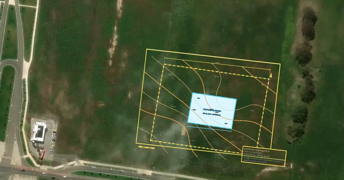
A PDF plan tells you what the engineer drew. It does not tell you that the access is off a divided road, that a service station sits on the next lot, or that the block is wider at the front than the title suggests. Until now you checked that in another tab. Now it sits under the drawing.
Map background is new in SitesAI Estimate. Type the job's address and real satellite imagery lands under your plan, already to scale. Line the two up and you can check the plan against the ground and measure straight off the photo in real metres. The video at the end of this post shows the whole thing in 53 seconds.
Step 1 — Add your plan and set its scale
Add the PDF, DXF or image from the + in the Layers panel and set the scale the usual way: type the ratio, or click a written dimension and enter its length. If you have not done that before, calibrating a PDF site plan takes about a minute. You can also skip it for now — see step 3.
Step 2 — Add a map background
Open + in the Layers panel again and choose Map background. Type the job address and press Find, pick the right match, choose how much ground to cover (200 to 800 metres square) and press Add map.
You can also paste coordinates or a Google Maps link instead of an address. The imagery is Esri World Imagery. In Australian cities it is sharp — around 12 to 24 centimetres per pixel — and where the finest level is not available the app steps down a level on its own.
The map goes to the bottom of the layer stack, north-up, under your plan. It is drawn at the same scale as your calibrated plans, so a metre on the photo is a metre on the drawing.
Step 3 — Line the plan up with two points
Open the plan layer's editor and press Align 2-Pt. Click two points on the plan, then the same two points on the photo: two lot corners, a kerb return, the edge of a slab. The plan moves, turns and sizes itself onto the ground.
If the plan had no scale yet, it takes the map's scale at this point and is marked as calibrated. If it already had one, aligning only moves it into place. Pick points far apart and easy to see on both — a 100-metre baseline is far more forgiving than a 10-metre one.
Step 4 — Check the site and measure off the photo
Now look at what the drawing does not show. Where the trucks get in. What the road reserve looks like. Trees, fences, a dam, the neighbour's shed on the boundary. Use the Dimension tool (switch Easy mode off to see it) to measure anything on the photo in real metres: the setback to the kerb, the run to the nearest crossover, the width of the access track.
In the video, the distance from the demonstration lot's boundary to the kerb of the main road measures 61.2 metres — straight off the photo, in the same project as the takeoff.
What it is good for — and what it is not
Use it to sense-check a plan before you price it, to plan access and haul routes, to spot what the drawing leaves out, and to explain a job to the crew. Use it when a client sends a sketch with no scale: align the sketch to two features on the photo and it has one.
Do not use it for set-out or anything you build to. Satellite imagery carries a few metres of positional error, the photo may be months or years old, and the ground may have changed since. The survey is still the survey.
The fine print
- Included on every plan, including Free. You need to be signed in.
- Nothing is stored in your file. The project keeps the location and zoom; the tiles load again when you open it. No internet, no photo — the plan and your takeoffs are unaffected.
- Your AI can do it too. Connected to Claude or ChatGPT through the SitesAI connector, you can ask it to "add a satellite background at the job address and line the plan up".
- Imagery: Esri, Maxar, Earthstar Geographics, and the GIS User Community. Address search: © OpenStreetMap contributors.
Try it on your next job at takeoff.sitesai.net — it is free to start. The plan in the video is demonstration data laid over public imagery to show the feature; it is not a real project.
Questions people ask
Does the map background cost extra?
No. It is included on every plan, including Free. You need to be signed in, because the imagery is fetched through our server.
How accurate is the satellite imagery?
Good enough to check a plan against the ground and to plan access, not for set-out. A few metres of positional error is normal for satellite imagery, and the photo can be months or years old. Build to the survey.
Is the imagery saved in my project file?
No. The project stores where the map is and at what zoom. The tiles load again when you open the project, so you need an internet connection to see them.
Can I use a Google Maps link?
Yes, to place the map. Paste the link or the coordinates into the address box. The imagery itself is Esri World Imagery.
Does it work outside Australia?
The imagery covers the world. Address search is set up for Australian addresses; anywhere else, paste coordinates or a map link.
Try it on your next plan set — free.
Sign in with Google or Microsoft, add a PDF or DWG/DXF, and see cut and fill in minutes. Pro is US$39 per user per month, the AI plan has a free 14-day trial; cancel any time. What SitesAI Estimate does.